Monday, March 25, 2013

Lakes (1)

Lake is a natural or man made water body of significat size with relatively still water.
There are various natural types of lakes. We will discuss important types by example.
We start with mountain lakes.
Mountains and river valleys of Northern Pakistan have formed through a constant process of landslides.
Rain, glaciers and stream water erodes and dissolves the base of all vallies that seeds further landslides. This process is very slow but never stops.
After every landslide ,stream or river in that valley tries to burst that natural dam. outcome depends upon size of river and landslide.
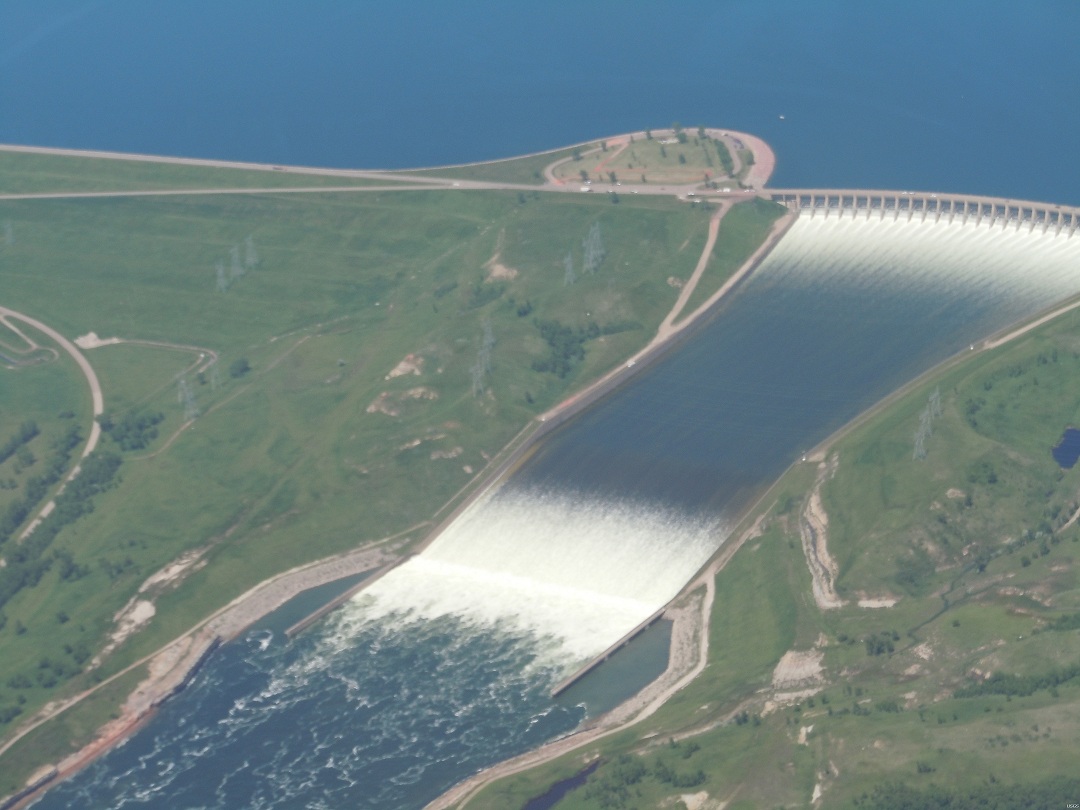
If stream is too small as compared to landslide, valley becomes a longer term lake, with a thin and long spillway and some waterfalls. Lake Saiful Muluk is one such example.


Attabad lake is a recent example of such phenomenon.
Attabad's landslide blocked Hunza river in 2010. Although river has better flowrate at that location, but amount of landslide was too big. This natural Lake will stay for a long time.


Pakistan is land of geographical extremes, and holds the record of biggest flood of recorded history. in Jan 1841, A Spur of Nanaga Parbat collapsed and blocked Indus river for about six months. This made a thousand meters high natural dam, that ultimately bursted in June 1841. estimated flow rate  of the flood wave was 190 lakh cusecs, about 20 times more than 2010 floods.


Another example is the lake Pangogng Tso, inside Indian occupied Kashmir and Tibet. About a hundred thousand years ago, this lake was cut-off from Indus river due to a massive landslide. This lake was the shooting site of last scenes of Bollywood movie 3 Idiots.


Tuesday, March 19, 2013

Pakistan's total annual water

Pakistan gets about 142 MAF of river water every year. I'v seen people arguing this figure for political reasons, and they say that actual annual water is as low as 106 MAF. we will discuss the cause and effects of this debate later, but let us see, how much water is it.

In first picture below, 142 MAF cube is parked near Karachi's international airport.
Second picture is zoomed out to compare it with map of Pakistan.


same water is hardly visible on map of Pakisatn
 

Monday, March 18, 2013

MAF cusecs relation

We read a lot of news about 'x' MAF of storage, or 'y' lakhs (hundred thousands) of cusecs of water, but do we know that how these two are related to each other?
Relation between these two can be explained in a single following line

"One MAF water is equal to 5 lakh cusecs flow for 24 hours"

We saw in flow example, flow rate depends upon volume change over a given time period.
This relation can be defined by a simple equation as following.

       flow = volume change / time

(Note: in engineering, symbol used for flowrate is Q, intutively it is a bit mis-guiding for non engineers, but F is reserved for force)

defining this relationship in SI units is much easier.
Example
we want to empty a lake of size 1 BCM ( billion cubic meter or a cubic kilometer).
lake has five drain tunnels, 1 cumec, 10 cumecs, 100 cumecs, 1000 cumecs and 10000 cumecs.
calculate the time for emptying the lake using each tunnel individually.

solution
we know that 
  flow = volume/time
 or  time = flow/volume
using this relationship, times taken for each tunnel to drain this lake are

1 cumec tunnel will take 1 billion seconds (more than 31 years) to drain this 1 BCM capacity lake
10 cumec tunnel will take 100 million seconds (about 3 years and 2 months) to drain this 1 BCM capacity lake
100 cumec tunnel will take 10 million seconds (about 17 weeks) to drain this 1 BCM capacity lake
1000 cumec tunnel will take 1 million seconds (about 12 days) to drain this 1 BCM capacity lake
10000 cumec tunnel will take 100000 seconds (about 28 hours) to drain this 1 BCM capacity lake

so, its not difficult to calculate these, but ...........we don't use metric units in Pakistan.
We use cusecs and MAF instead,  which adds an additional step in the relation.

concept is same, flow = volume/time, but we have to plug the value of acre foot (1 acre foot = 43560 cubic feet)
let us do some realistic math in next example.
Example
Tarbela's reservoir has a live storage capacity of 6.8 MAF.
with net impounded inflow of 200000 cusecs, how many days will it take to fill the lake?

Solution
don't worry about the complex terms involved, concept is as simple as tub and tap.
we simply have to plug in the value of 1 acre foot = 43560 cubic feet
let's do it.
we know that flow  = volume/time
hence   time = volume/flow
or  time = (6800000 acre foot)/(200000 cusec)
      time = (6800000  x 43560)/(200000 cusec)
      time = 1481040 seconds
 or            17.14 days

a useful conversion thumb rule
  volume = flow x time
  volume (acre feet in one second)     = (cusecs /43560)
  Volume (MAF in a day) = (cusecs x 86400) / (43560 x 1000000)

another example
Calculate volume of water involved in a flow of 500000 cusecs for one day
  Volume (MAF in a day) = (cusecs x 86400) / (43560 x 1000000)
       = 500000 x 86400) / (43560 x 1000000)
       = 0.99173 MAF
      
  in short, 5 lakh cusecs flow for a day involves about one MAF water

Sunday, March 17, 2013

Units and Measurements 2(Flow)


You don't need to know calculus to understand water flow measurements. The math involved is easier for a high school student, as without noticing, we practice similar rate measurements in everyday life like speed or wages.


Water flow is commonly measured as amount of water flowing every second.
For example, if a tap connected with a 100 liters tank empties it in 100 seconds, tap's flow rate is 1 litre per second.
Similarly if a tap fills a 100 liters tub in 100 seconds, tap's flowrate is 1 litre per second.
for bigger flows like canal or river flow, cusecs and cumecs are used.

1 Cusec flow is 1 cubic meter per second.
1 Cumec flow is 1 cubic meter per second.
Cumec is comparatively  bigger unit. It is iequal to 35.3147 cusecs
Cusec is most commonly used flow rate unit in Pakistan.

many large irrigation canals and link canals in Pakistan have flow rates between 10 to 25 thousand cusecs.

Our rivers have obviously larger average flowrates during summer, ranging from 50 to 250 thousand cusecs

 2010 Indus flood was measured around 1250 thousand cusecs in Sindh.
 

Friday, March 15, 2013

Units and Measurements 1(Volume)

Here are some useful units used in Pakistan
Land measurements
Murabba Gaz (square yard) = 3 feet x 3 feet
1 Karm = 3.361 Murabba Gaz (square yards)
1 Marla = 9 Karm
1 Kanal = 20 Marlas
1 Killa = 1 Acre =8 Kanals (4,840 square yards or 43,560 square feet)

one acre was historically considered as the amount of land a yoke of oxen could plough in one day
another bigger unit is Murabba, a status symbol in Agriculture of Pakistan. its size varies, but usually it is considered equal to 25 Acres

Volume measurements
Most countries use cubic meter as the basic unit for water volume.


Acre foot
water measurements in Pakistan are mostly done in acre foot.
it is simply the amount of on foot deep water on an area of one acre.
1 acre foot = 1233.48184 cubic meters


million acre foot (MAF) is commonly used to measure large volumes of water.


similarly billion cubic meter (BCM) is used in countries following SI system.

1 million acre feet (MAF) = 1.23348184 Billion cubic meters (BCM)

Monday, March 11, 2013

Contours

Contours
Contours are used to show elevations in a flat map.


A contour line on map connects the path of fixed elevation points across a map. Contour interval is the difference of height between two adjacent contour lines. Different maps may have different contour intervals depending upon the scale or area type.

In a map, more distance between adjacent contours reflects flatter area, while crowded contours tell about steepness of a feature.
every fifth contour line is kept thicker for ease of counting.
try to find contour lines in this map of Muzaffarabad.

In computer age, we have many new ways to visualize and compute a 3D area, but this hasn't harmed the usefulness of contours.
contours are used to design drainage channels, canals, roads, railway lines or calaculate the capacity of a new lake. Military maps need contours for planning operations.
Before computers, contour maps were costly to make, and modify. It included aerial survey, photogrammetry and stereoscopy to manually draw contour maps.
Nowadays, satellites generate data elevation models of globe with
computerized 3D terrain data-sets have made life much easier. custom contours can be drawn in seconds with flexibility of detail and resolution.
It took few seconds to draw contours of Karakorams near K-2 in the picture below. Before computers, it would have taken years if not decades to draw such a map.
 

Slope

Slope
We use word slop in everyday conversation, and it means the same in engineering.
slop is the rate of rise or fall of a line or surface, as it moves forward.
see the picture below, and it will confirm your experience that mild slopes are easy to climb, and steep slopes are harder.

for calculations, we can use any of intutive ways to define a slope.
it can be angle of the inclination, percentage rise or ratio of height difference vs distance travelled.

Water always travels down a slope and it travels faster on a steeper slope. it can not travel up a slope.


riverbeds (path of a river) have very mild slope in planes, but are steeper in hilly or mountaineous areas. still riverbed has the easiest slope inside montain areas. Permanent roads in mountains are always constructed along a river bank to avoid bad slopes. Karakoram highway is a common example.


In an area with seasonal rivers, like Balochistan, mostly dry stream beds can be used as natural roads for traveling, but be aware of flash floods.


riverbeds are steepest inside nerrow valleys and gorges. we will discuss this topic in detail on a separate page.

Saturday, March 9, 2013

Another water map of Pakistan

Another water map of Pakistan
This is another map I made with bare hands. It was much faster after the experience of rivers map, but still took a year to collect and plot day to day and point to point data.
It shows canals and distributaries of Irrigation system under Tarbela and Mangla command. I will share a complete irrigation system map including Khyber Pakhtunkhwa and Balochistan soon.
 

Friday, March 8, 2013

A very special map of Pakistan

A very special map of Pakistan

Attached map may look like just another map you can search on Google.
Think again, It is a zoomed out view of a very detailed three dimensional digital hydrology map of Pakistan, with historical, mean, min and max rain fall and stream flow data mapped on it,  that is dozens time more accurate than any existing river map in the world. I have switched off data in the map, because it is confidential, and covers entire map at this zoom level if turned on.
With help of a computer, a similar map without embeded data with fairly acceptable accuracy can be generated in 5-10 minutes.
What makes this map special is that it is not computer generated, but is handcrafted. I made it with free hand in over 3 years, just to "feel every curve" of my motherland. Can't call this exercise a wasted time, because it has taught me so many things about hydrology and Pakistan, that books could never teach.
I have uploaed it in an unusual size for a bolg, but actual digital map can be zoomed in upto a  resolution of 6-12 inches on ground per screen pixel.
Note: smaller streams are still turned-off for a better view


Monsoon: a rare natural phenomenon

Monsoon: a rare natural phenomenon

Monsoon is a spectacular natural phenomenon for Indo-Pak subcontinent, South-East and East-Asia.


Winds switch direction twice a year due to difference of sea and land temperatures.
 

Summer winds bring a lot of moisture from Indian ocean, that causes very wet rainy seasons.
Indian peninsula is almost the same size of Arabian peninsula, but due to Monsoon water, it is able to support about 5000% more population.

Tibetan Plateau: Roof of the world

 
Tibetan Plateau: Roof of the world
This is a satellite view of Tibet plateau. Tibet is called roof of the world because it is about 5000 meters higher than its surroundings.

Indo-Ganges basin below it is green and firtile because Himalayas and Karakorams on plateau's south get a lot of rain and snow from monsoon in summer and mediterranean winds in winter.
Sandy Taklamakan desert in Chinese Turkestan (Xinjiang ),north of Tibet is gets very little rain. some Tibetan rivers drain towards north to support populations of old cities like Kashghar, Yarkand and Khotan.

Eastern part of Tibet is the origin of  few largest rivers on earth, that support the life in China, South east Asia and South Asia.
Rivers from western Tibet reach pakistan and centeral Asia.

You can see many lakes in the middle of Tibet. It shows that this area didn't get rains necessary to make rivers long enough to reach the sea.
 

Glaciers and mountains

Glaciers and mountains
Following pictures are same, except lower one has some lines added for illustration.


Let us discuss, how glacier made this valley. (You can click the pictures in this blog to enlarge them)
Yellow area in second picture shows the boundary of a glacier.
notice the red line, it makes the boundary that connects the highest points around this glacier. Any snow that falls within this boundary will become the part of this glacier.
Blue lines show the course of melting water, or semi melted snow.
As more snow falls, it will slide down the steep cliffs sooner or later, and will push the glacier further.
As the icy glacier moves, it will grind and cut more rubble from the rocks in its valley.
In long term, it makes the slopes on both sides unstable, and extra parts of the slopes fall down as a landslide to be carried away along the glacier.
Earthquakes speed up such landslides.(Remember mountain areas get more earthquakes)
Millions of years ago, area bounded by red line was almost a flat plateau. It has achieved this shape over time.
We can say "glaciers carved out these mountains".

Earthquakes

Earthquakes
Have a look at the world map of recorded earthquakes during last 115 years.
We will see later how earthquakes are related to our topic, but there are few important conclusions this map can teach us.

1. Earthquakes are strongly related to plate tectonics. (occur on plate boundaries)
2. Tectonic plates emerge with mild earthquakes.
3. Stronger earthquakes occurs where tectonic plates collide.
4. Plate's subduction zones get most and strongest earthquakes.
5. Mountaineous areas get more earthquakes than plane areas.
 

Thursday, March 7, 2013

Glaciers

Glaciers
Glaciers are slow rivers of ice.
High mountains get snow instead of rain, and a lot of it.
When snow layer gets too thick, it becomes hard ice due to its enormous weight.
While more snow falls on higher parts of mountain, it pushes the older snow down.
this push of weight keeps glaciers "flowing".
Glaciers move very slowly, just few inches to few feet per day. but they roughly grind the rockey surface beneath them, and this grinding carves the valleys for snow fed rivers.
When glacier moves down a mountain, it gets wider area ahead to occupy, thats why their front end further slows down.
lower end of glacier melts faster, because it is wider, slower and at a warmer place than top of mountain. this gives birth to snow fed rivers.


glacial river network forms in a similar way as rivers in plane. small streams find their way to join together and keep growning and moving towards low lands.
Ultimately every river "wants" to get out of mountains towards the sea.
Glacier fed rivers are more steady and most of them flow around the year, due to few or many glaciers at their back end.
Glacier size grows in winter and shrink in Summer, due to temperature and new snowfall.
When a glacier size shrinks year to year, we can say that area is warming or new snowfall is decreasing. Picture below shows retreat of Muir Glacier in Alaska over 63 years of warming.


Global warming will melt most of glaciers in Pakistan unless nature invents a new way to reset the balance of snaowfall.
When a glacier disappears, the stream or river it feeds, shuts down.

Wednesday, March 6, 2013

Why Mountains are there?

Why Mountains are there?
Planet Earh is like an egg, filled with hot molten lava.
Earth's solid crust is 10 to 50 kilometers thick, that covers the inner side like an egg shell.
Earth's crust is not a single piece and its large floating continet sized pieces are called Tectonic plates.
Tectonic plates grow out like finger nails, mostly underneath the oceans, and drift apart few inches per year.
These Tectonic plates move steadily due to thrust of molten lava beneath them, and interact with each other in different ways.
they can collide, grind or subdue each other, causing earthquakes and wrinkles on the crust.
These "wrinkles" are quiet big in size and become mountains.


Most interesting type of this interaction happened between Indian plate and Eurasian plate. Instead of smoothly sliding past, they got locked against each other. While Indian plate keeps on pushing, it has raised the Tibet several miles high above its original level, causing the highest plateau and mountains on the earth. This unique situation supports more than half of the human population on our planet.


Tuesday, March 5, 2013

Total water on the Earth

Total water on the Earth
Here is a nice picture to understand how much water exists on our planet. I have removed the complex details, but you hac view them here


Total water on Earth

The largest sphere represents all of Earth's water, and its diameter is about 860 miles. The sphere includes all the water in the oceans, ice caps, lakes, and rivers, as well as groundwater, atmospheric water, and even the water in you, your dog, and your tomato plant.

Liquid fresh water

How much of the total water is fresh water, which people and many other life forms need to survive? The blue sphere over Kentucky represents the world's liquid fresh water (groundwater, lakes, swamp water, and rivers).

Water in lakes and rivers

Do you notice that "tiny" bubble over Atlanta, Georgia? That one represents fresh water in all the lakes and rivers on the planet, and most of the water people and life of earth need every day comes from these surface-water sources


The data used on this page comes from Igor Shiklomanov's estimate of global water distribution.
 

What is a River?

What is a River
Rain water, after touching the ground, tries to find its way to lowest available depression or ditch.
when first depression fills, water overflows and extra water finds next closest ditch.
with every rain, new water dissolves and transports some extra earth along it, over the time the chain of connected puddles transforms into well defined stream bed.


over millions of years, this continuous pattern of water defines the path for a runoff stream, that drains the rainwater as it arrives.
these streams follow a random path in start, and when they accidently meet another stream, they join together.
a tree of such streams keeps growing downstream and so does the amount of water it contains.
when a stream is big enough, we call it a river. although an intermittent river , ( a river that flows only in a rainy season). I will come back to continuous rivers after covering some related definitions and topics.

there are few laws that water strictly follows.
1. water always flow towards lower area, so direction of strem tells which area is lower than other. this slope may be so slight that naked eye cannot feel it, but water feels it easily.
Don't think that water is intelligent, it is just lazy.
Well since laziest people are good at discovering the easit way to do things, exactly the same way,  water, due to its weight cannot rise at its own, it always drops and flows towards lower side. using this property, people invented water based leveling tools for construction and measurements several thousand years ago, that are still in use. Such tools were used in construction of Egyptian pyramids, and haven't changed a lot over the time.


2. River never flows backwards, towards higher ground. it is a common wisdom, but has solid scientific logic to support it. there are some exceptions but it happens due to special situation following the same underlying law.


Common Water Wisdom

Common Water Wisdom

Water has played a major role in the physical and social shape of the world as we know it today.
Water is the difference between wasteland and a lush forest full of life.
On the world map, human and wildlife growth follows the pattern of drinkable water availability.
Rain in a certain region decides the sustainablility of plant and animal life. for humans, sustainable underground water amount is an additional resource.
Availability of other climatic conditions such as temperature and sunlight have their own importance.An area where all three of them are available, makes the perfect combination.
That's why earliest and and most stable civilizations like Iraq, Egypt and Indus valley, all emerged and flourished in such conditions.


Kabul River basin

Kabul River
Pakistan and Afghanistan share Kabul sub-basin as a part of Indus basin.
Map shows the complete picture of Kabul basin. Its north east part gets the most water from Pakistan's Chitral region. Average annual flow from Chitral is 7.59 MAF
south west branches from Afghanistan's Logar and Wardak provinces contribute very little water, but Panjsher and Ghorband rivers in kabul's north have beter snow and ice resources.
Average annual flow of river just before it re-enters Pakistan from Nangarhar, is 15.683 MAF