Sunday, April 21, 2013

A barrage for nothing


Khanki barrage was built in 1892 and it has successfully commanded Lower Chenab canal for 120 years.
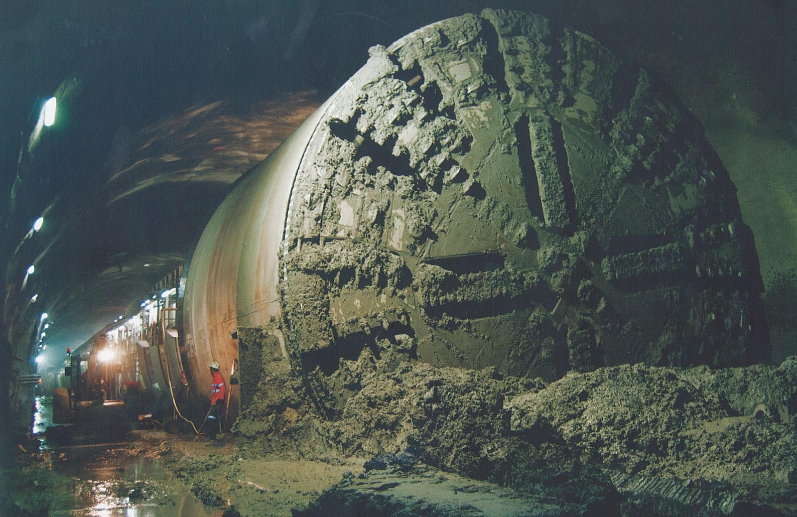
few years ago, govt decided to abolish the aged structure and replace it with a new barrage few hundred meters downstream.
Asian Development Bank is financing the project but there is a serious issue that makes the entire project redundant and a waste of hundreds of millions of public money dollars.
Ironically, this issue was never considered during the project study.

During construction of Rasul-Qadirabad-Balloki-Sulemanki link under Indus water treaty, Khanki at Chenab was 10+ meters higher and 29 km upstream, that's why Qadirabad barrage was built instead.
As visible in the attached map, effectively, 98.2% of Lower chenab canal's command area lies below QBLink. which means Qadirabad barrage can command both QB link and Lower Chenab.


currently, QB link carries some ~30% water for LCC command through LCC Feeder and it may be possible to increase it to 100% for first 25 Km stretch (till head Sagar), or a parallel canal segment with independent elevation can be used.

LCC Qmax is below 10000.
QB link operates @ 22000 cusecs as compared to its design max of 27000.
it means it is an issue of additional 5000 cusecs. which can be achieved by slight increase in crest and/or width of canal.


Entire arrangement will look very much like Marala or Balloki headworks.
See attached cross sectional design of QB link between its head regulator and Head Sagar complex.

While WAPDA is already working on Mangla-Marala link canal, 1.8% of LCC command area above QBlink can be re-assigned to Upper Chenab canal. additional water is not an issue.
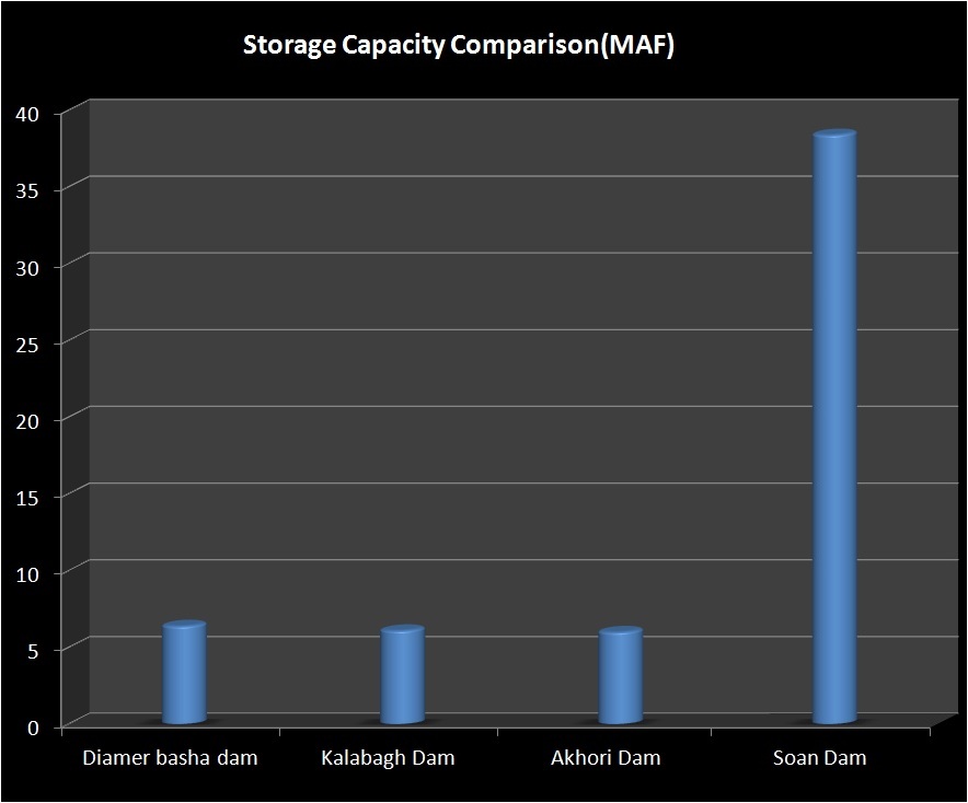
 Khanki may be useful for some flood control, but proposed Chiniot reservoir downstream has much better capacity and location to do the same.
Conclusion: New Khanki Barrage is an unnecessary waste of public money. Qadirabad Barrage can do the same job with minor adjustments.

Construction preparations have already started and this "barrage for nothing" is set to complete by 2016.

Tuesday, April 16, 2013

Water borders of South Punjab

South Punjab has been long neglected area regardless of being the agricultural back-bone of Pakistan.
During last few years, division of Punjab has become a popular issue, partially due to linguistic, administrative concerns and to some extent, vote bank politics.

Infrastructure and water is a big factor to consider for such issues.

If South Punjab becomes a separate province, there needs to be a careful study to divide the water share, resources, channels and barrages between North and South Punjab.

Most important question will rise about division of Indus river's water. currently Sindh gets much more water per unit area than Punjab. In my opinion, People's Party will back off from the issue, again for votebank politics in home province.

Here are some related maps for my readers.
1. Chenab River Irrigation Command Area
In simple words, area marked green can be irrigated with Chenab river's water.


2. Jhelum River Irrigation Command Area
Area marked yellow can be irrigated with Jhelum river's water, and can use Mangla dam's storage.


3. Indus River Irrigation Command Area
Area marked blue can be irrigated with Indus river's water, and can useTarbela's stored water.


SuperImposing these three river commands, makes this picture.


let us turn on the administrative borders of divisions.

Districts make it complex.

Annotated map for reference


Canals and Barrages make it much more complex

Note: This post is not to support or oppose the issue. it is just for education of Pakistani people to understand the water issues tied with a new province.

Tuesday, April 9, 2013

Soan Dam project overview

In coming days, I will break down the design nitty gritty, and publish on this blog.

Here is an overview of Soan Dam project
Soan reservoir will keep Tarbela near dead level during summer, and will collect water as it arrives. Soan lake can store up to 6 times more water than Tarbela, Kalabagh or Diamer Basha dam. This will keep Tarbela ever-ready for floods, and eliminate chances of co-inciding floods in Peshawar valley.


Water's economic value in this project is dozens time more than hydel power, but there is a lot of hydel potential too, in fact more than existing hydel capacity of WAPDA.

Summer Water will be transferred using combination of Tunnels and fast channel like Ghazi Barotha Canal.
similar power channel at exit can tap more hydroelectricity than Kalabagh dam.

We have experience of making and maintaining such structures.


Sunday, April 7, 2013

Soan Reservoir calculations

Here are some basic numbers about Soan reservoir size, using two different elevation data sets for accuracy and cross checking.

Both datasets are off by 10 meters in abosolute elevation at area of interest.
but it doesn't effect the capacity or functional design of project, because in both cases, entire volume of lake comfortably lies below the required elevation, i.e, Tarbela's dead level (420 meters) with upto 20 meters head available for transferring water from Tarbela to Soan.


SRTM DEM V4.1 (one used inside google earth)
The Shuttle Radar Topography Mission (SRTM) is an international research effort that obtained digital elevation models on a near-global scale from 56° S to 60° N,[2] to generate the most complete high-resolution digital topographic database of Earth prior to the release of the ASTER GDEM in 2009. SRTM consisted of a specially modified radar system that flew on board the Space Shuttle Endeavour during the 11-day STS-99 mission in February 2000, based on the older Spaceborne Imaging Radar-C/X-band Synthetic Aperture Radar (SIR-C/X-SAR), previously used on the Shuttle in 1994. To acquire topographic (elevation) data, the SRTM payload was outfitted with two radar antennas.[2] One antenna was located in the Shuttle's payload bay, the other – a critical change from the SIR-C/X-SAR, allowing single-pass interferometry – on the end of a 60-meter (200-foot) mast[2] that extended from the payload bay once the Shuttle was in space. The technique employed is known as Interferometric Synthetic Aperture Radar.

The elevation models are arranged into tiles, each covering one degree of latitude and one degree of longitude, named according to their south western corners. It follows that "n45e006" stretches from 45°N 6°E to 46°N 7°E and "s45w006" from 45°S 6°W to 44°S 5°W. The resolution of the raw data is one arcsecond (30 m), but this has only been released over United States territory. A derived one arcsecond dataset (with trees and other non-terrain features removed) covering Australia was made available in November 2011; the raw data are restricted for government use.[3] For the rest of the world, only three arcsecond (90 m) data are available.[4] Each one arcsecond tile has 3,601 rows, each consisting of 3,601 16 bit bigendian cells. The dimensions of the three arcsecond tiles are 1201 x 1201.

The elevation models derived from the SRTM data are used in Geographic Information Systems. They can be downloaded freely over the Internet, and their file format (.hgt) is supported by several software developments.

The Shuttle Radar Topography Mission is an international project spearheaded by the U.S. National Geospatial-Intelligence Agency (NGA) and the U.S. National Aeronautics and Space Administration (NASA).


ASTER GDEM
ASTER (Advanced Spaceborne Thermal Emission and Reflection Radiometer) is a Japanese sensor which is one of five remote sensory devices on board the Terra satellite launched into Earth orbit by NASA in 1999. The instrument has been collecting superficial data since February 2000.

ASTER provides high-resolution images of the planet Earth in 14 different bands of the electromagnetic spectrum, ranging from visible to thermal infrared light. The resolution of images ranges between 15 to 90 meters. ASTER data are used to create detailed maps of surface temperature of land, emissivity, reflectance, and elevation.


Soan Reservoir

Soan Reservoir site stretches from Dhok Pathan bridge towards Rawalpindi.

To collect South Punjab's flood water share, 15 to 17 MAF lake will be enough.
In order to make it a national reservoir, 35-38 MAF will be "optimum over-design".
Thus Sparing 6-8 MAF for Indus delta flows, and 25-30 MAF for winter and late spring water needs in all provinces.

Picture is worth a thousand words, following two maps shows lake sizes for 17 and 38 MAF capacity.

17 MAF Soan Lake

39 MAF Soan Lake
 

Tuesday, April 2, 2013

Soan Dam Comparison

Here are two graphs showing the comparison of Soan Dam vs other alternatives.

First graph shows the storage capacity, Soan valley can collect much more water than all other options put together.


Price wise it is very economical for unit storage, again 6-10 times cheaper than others
 

Monday, April 1, 2013

The Indus of Pakistan

I made this short documentary last year.

It was made to educate people about Indus river, its blessings, sorrows and solutions to them.

Here are links

Facebook:
https://www.facebook.com/photo.php?v=10151343108971478&set=vb.537506477&type=2&theater


Vimeo: for Pakistan where youtube is banned
http://vimeo.com/62972400

 
Youtube Video


Soan Dam: Bright future of Pakistan

I have to jump to a different topic today.After that we will go back to our regular topics list, to resume the general learning curve.
I have published this topic in Urdu to soften the sudden jump of concepts.

Back in 2010, I designed a detailed flood control system for Pakistan, to tame and harvest super floods. It includes several proposed sites for large scale water storage. I presented it at govt level in Pakistan in Jan 2011.

two years later, it is elections season and I feel that people of Pakistan have a right of awareness and discussion over this topic.
Back in December 2012, media wasted a whole month of prime air time about Lahore High court's decision on Kalabagh dam. They need better topics.

I am not sure if it will get due attention in next 4-5 weeks, but I have to do my part.
I will publish seversal posts on this topic, including video and some technical details.

[update on 6/6/2013] Elections are over with new govt in place now. I guess WAPDA already knows and remembers Soan dam, but govt. and media needs to pay some attention to ideas like this in middle of shambled economy and prevailing hopelessness.
This is much better option than IMF/WB bail-outs or foreign aid.


Here is urdu summary of the project.