Monday, March 11, 2013

Slope

Slope
We use word slop in everyday conversation, and it means the same in engineering.
slop is the rate of rise or fall of a line or surface, as it moves forward.
see the picture below, and it will confirm your experience that mild slopes are easy to climb, and steep slopes are harder.
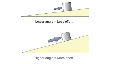
for calculations, we can use any of intutive ways to define a slope.
it can be angle of the inclination, percentage rise or ratio of height difference vs distance travelled.

Water always travels down a slope and it travels faster on a steeper slope. it can not travel up a slope.


riverbeds (path of a river) have very mild slope in planes, but are steeper in hilly or mountaineous areas. still riverbed has the easiest slope inside montain areas. Permanent roads in mountains are always constructed along a river bank to avoid bad slopes. Karakoram highway is a common example.


In an area with seasonal rivers, like Balochistan, mostly dry stream beds can be used as natural roads for traveling, but be aware of flash floods.


riverbeds are steepest inside nerrow valleys and gorges. we will discuss this topic in detail on a separate page.

Saturday, March 9, 2013

Another water map of Pakistan

Another water map of Pakistan
This is another map I made with bare hands. It was much faster after the experience of rivers map, but still took a year to collect and plot day to day and point to point data.
It shows canals and distributaries of Irrigation system under Tarbela and Mangla command. I will share a complete irrigation system map including Khyber Pakhtunkhwa and Balochistan soon.
 

Friday, March 8, 2013

A very special map of Pakistan

A very special map of Pakistan

Attached map may look like just another map you can search on Google.
Think again, It is a zoomed out view of a very detailed three dimensional digital hydrology map of Pakistan, with historical, mean, min and max rain fall and stream flow data mapped on it,  that is dozens time more accurate than any existing river map in the world. I have switched off data in the map, because it is confidential, and covers entire map at this zoom level if turned on.
With help of a computer, a similar map without embeded data with fairly acceptable accuracy can be generated in 5-10 minutes.
What makes this map special is that it is not computer generated, but is handcrafted. I made it with free hand in over 3 years, just to "feel every curve" of my motherland. Can't call this exercise a wasted time, because it has taught me so many things about hydrology and Pakistan, that books could never teach.
I have uploaed it in an unusual size for a bolg, but actual digital map can be zoomed in upto a  resolution of 6-12 inches on ground per screen pixel.
Note: smaller streams are still turned-off for a better view


Monsoon: a rare natural phenomenon

Monsoon: a rare natural phenomenon

Monsoon is a spectacular natural phenomenon for Indo-Pak subcontinent, South-East and East-Asia.


Winds switch direction twice a year due to difference of sea and land temperatures.
 

Summer winds bring a lot of moisture from Indian ocean, that causes very wet rainy seasons.
Indian peninsula is almost the same size of Arabian peninsula, but due to Monsoon water, it is able to support about 5000% more population.

Tibetan Plateau: Roof of the world

 
Tibetan Plateau: Roof of the world
This is a satellite view of Tibet plateau. Tibet is called roof of the world because it is about 5000 meters higher than its surroundings.

Indo-Ganges basin below it is green and firtile because Himalayas and Karakorams on plateau's south get a lot of rain and snow from monsoon in summer and mediterranean winds in winter.
Sandy Taklamakan desert in Chinese Turkestan (Xinjiang ),north of Tibet is gets very little rain. some Tibetan rivers drain towards north to support populations of old cities like Kashghar, Yarkand and Khotan.

Eastern part of Tibet is the origin of  few largest rivers on earth, that support the life in China, South east Asia and South Asia.
Rivers from western Tibet reach pakistan and centeral Asia.

You can see many lakes in the middle of Tibet. It shows that this area didn't get rains necessary to make rivers long enough to reach the sea.
 

Glaciers and mountains

Glaciers and mountains
Following pictures are same, except lower one has some lines added for illustration.


Let us discuss, how glacier made this valley. (You can click the pictures in this blog to enlarge them)
Yellow area in second picture shows the boundary of a glacier.
notice the red line, it makes the boundary that connects the highest points around this glacier. Any snow that falls within this boundary will become the part of this glacier.
Blue lines show the course of melting water, or semi melted snow.
As more snow falls, it will slide down the steep cliffs sooner or later, and will push the glacier further.
As the icy glacier moves, it will grind and cut more rubble from the rocks in its valley.
In long term, it makes the slopes on both sides unstable, and extra parts of the slopes fall down as a landslide to be carried away along the glacier.
Earthquakes speed up such landslides.(Remember mountain areas get more earthquakes)
Millions of years ago, area bounded by red line was almost a flat plateau. It has achieved this shape over time.
We can say "glaciers carved out these mountains".

Earthquakes

Earthquakes
Have a look at the world map of recorded earthquakes during last 115 years.
We will see later how earthquakes are related to our topic, but there are few important conclusions this map can teach us.

1. Earthquakes are strongly related to plate tectonics. (occur on plate boundaries)
2. Tectonic plates emerge with mild earthquakes.
3. Stronger earthquakes occurs where tectonic plates collide.
4. Plate's subduction zones get most and strongest earthquakes.
5. Mountaineous areas get more earthquakes than plane areas.