Saturday, August 24, 2013

Dastak Ep91 - Soan Dam Better Alternative of Kalabagh Dam


Dastak episode on Rawal TV Canada about Soan Dam project.
Media exposure will help build necessary awareness for this useful project.

TV Channels inside Pakistan haven't fould this topic very interesting, at least till now. we live in interesting times :-)


YouTube link


Alternate links for locations with no YouTube access

DailyMotion Link
http://www.dailymotion.com/video/x13b38o_dastak-ep91-soan-dam-better-alternative-of-kalabagh-dam_tech

Vimeo Link
http://vimeo.com/72627588


Thursday, May 16, 2013

Marib Dam


Building a dam on a river, to store extra water for irrigation is an old skill learned by humans.

Oldest example is Maarib dam in Yemen, that is mentioned in Quran.


This dam lasted for thousands of years before finally collapsing in a catastrophe.

Maarab/Arim was the town of Queen Bilqis on eastern slopes of Yemen's San'a highlands.


Ma'rib dam was constructed about four thousand years ago.

It had right and left bank canals to sustain a lush green oasis in the desert.
Collapse happend before the dawn of Islam, which forced the Yemenite Arab tribes to spread north into Hejaz, Iraq and Syria.

Surah Saba 34/14,15
لَقَدۡ كَانَ لِسَبَإٍ۬ فِى مَسۡكَنِهِمۡ ءَايَةٌ۬ ۖ جَنَّتَانِ عَن يَمِينٍ۬ وَشِمَالٍ۬ۖ كُلُواْ مِن رِّزۡقِ رَبِّكُمۡ وَٱشۡكُرُواْ لَهُۚ ۥ بَلۡدَةٌ۬ طَيِّبَةٌ۬ وَرَبٌّ غَفُورٌ۬
فَأَعۡرَضُواْ فَأَرۡسَلۡنَا عَلَيۡہِمۡ سَيۡلَ ٱلۡعَرِمِ وَبَدَّلۡنَـٰهُم بِجَنَّتَيۡہِمۡ جَنَّتَيۡنِ ذَوَاتَىۡ أُڪُلٍ خَمۡطٍ۬ وَأَثۡلٍ۬ وَشَىۡءٍ۬ مِّن سِدۡرٍ۬ قَلِيلٍ۬
There was indeed a sign for Sheba in their dwelling-place: Two gardens on the right hand and the left (as who should say): Eat of the provision of your Lord and render thanks to Him. A fair land and an indulgent Lord! (15) But they were froward, so We sent on them the flood of 'Iram, and in exchange for their two gardens gave them two gardens bearing bitter fruit, the tamarisk and here and there a lote-tree.

During 1990s, another dam has been built, two miles upstream from the old site. New Marib dam has restored the agriculture of this lost civilization.

its picture can bee seen on local currency as a sign of construction and prosperity.


Sunday, April 21, 2013

A barrage for nothing


Khanki barrage was built in 1892 and it has successfully commanded Lower Chenab canal for 120 years.
few years ago, govt decided to abolish the aged structure and replace it with a new barrage few hundred meters downstream.
Asian Development Bank is financing the project but there is a serious issue that makes the entire project redundant and a waste of hundreds of millions of public money dollars.
Ironically, this issue was never considered during the project study.

During construction of Rasul-Qadirabad-Balloki-Sulemanki link under Indus water treaty, Khanki at Chenab was 10+ meters higher and 29 km upstream, that's why Qadirabad barrage was built instead.
As visible in the attached map, effectively, 98.2% of Lower chenab canal's command area lies below QBLink. which means Qadirabad barrage can command both QB link and Lower Chenab.


currently, QB link carries some ~30% water for LCC command through LCC Feeder and it may be possible to increase it to 100% for first 25 Km stretch (till head Sagar), or a parallel canal segment with independent elevation can be used.

LCC Qmax is below 10000.
QB link operates @ 22000 cusecs as compared to its design max of 27000.
it means it is an issue of additional 5000 cusecs. which can be achieved by slight increase in crest and/or width of canal.


Entire arrangement will look very much like Marala or Balloki headworks.
See attached cross sectional design of QB link between its head regulator and Head Sagar complex.

While WAPDA is already working on Mangla-Marala link canal, 1.8% of LCC command area above QBlink can be re-assigned to Upper Chenab canal. additional water is not an issue.
 Khanki may be useful for some flood control, but proposed Chiniot reservoir downstream has much better capacity and location to do the same.
Conclusion: New Khanki Barrage is an unnecessary waste of public money. Qadirabad Barrage can do the same job with minor adjustments.

Construction preparations have already started and this "barrage for nothing" is set to complete by 2016.

Tuesday, April 16, 2013

Water borders of South Punjab

South Punjab has been long neglected area regardless of being the agricultural back-bone of Pakistan.
During last few years, division of Punjab has become a popular issue, partially due to linguistic, administrative concerns and to some extent, vote bank politics.

Infrastructure and water is a big factor to consider for such issues.

If South Punjab becomes a separate province, there needs to be a careful study to divide the water share, resources, channels and barrages between North and South Punjab.

Most important question will rise about division of Indus river's water. currently Sindh gets much more water per unit area than Punjab. In my opinion, People's Party will back off from the issue, again for votebank politics in home province.

Here are some related maps for my readers.
1. Chenab River Irrigation Command Area
In simple words, area marked green can be irrigated with Chenab river's water.


2. Jhelum River Irrigation Command Area
Area marked yellow can be irrigated with Jhelum river's water, and can use Mangla dam's storage.


3. Indus River Irrigation Command Area
Area marked blue can be irrigated with Indus river's water, and can useTarbela's stored water.


SuperImposing these three river commands, makes this picture.


let us turn on the administrative borders of divisions.

Districts make it complex.

Annotated map for reference


Canals and Barrages make it much more complex

Note: This post is not to support or oppose the issue. it is just for education of Pakistani people to understand the water issues tied with a new province.

Tuesday, April 9, 2013

Soan Dam project overview

In coming days, I will break down the design nitty gritty, and publish on this blog.

Here is an overview of Soan Dam project
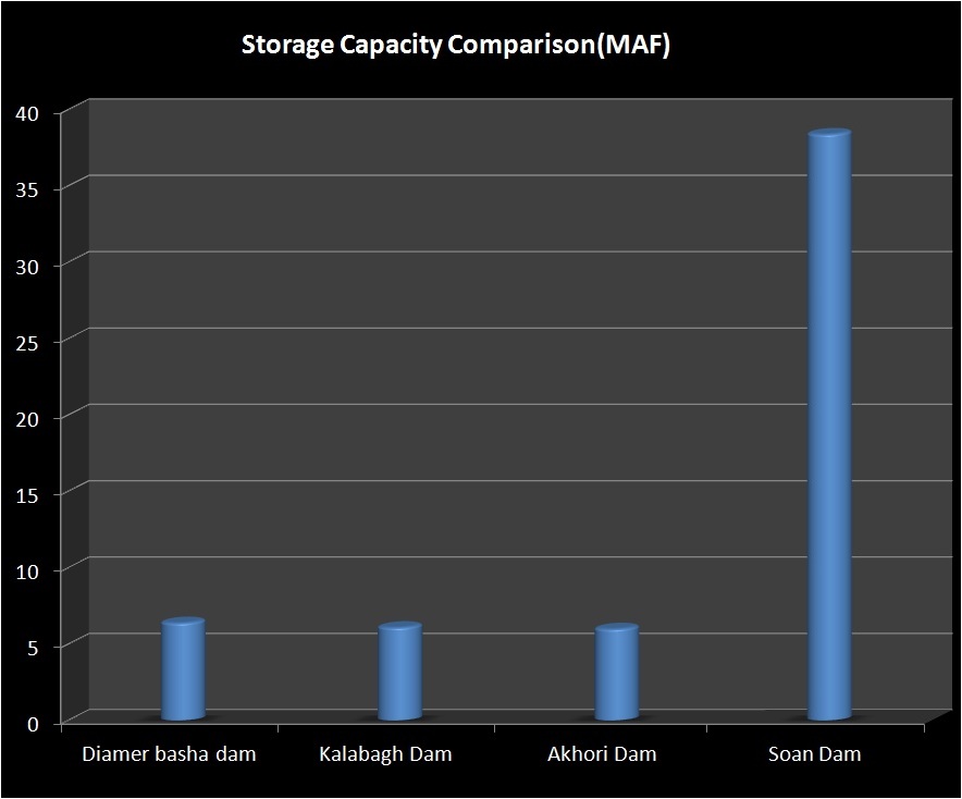
Soan reservoir will keep Tarbela near dead level during summer, and will collect water as it arrives. Soan lake can store up to 6 times more water than Tarbela, Kalabagh or Diamer Basha dam. This will keep Tarbela ever-ready for floods, and eliminate chances of co-inciding floods in Peshawar valley.


Water's economic value in this project is dozens time more than hydel power, but there is a lot of hydel potential too, in fact more than existing hydel capacity of WAPDA.

Summer Water will be transferred using combination of Tunnels and fast channel like Ghazi Barotha Canal.
similar power channel at exit can tap more hydroelectricity than Kalabagh dam.

We have experience of making and maintaining such structures.


Sunday, April 7, 2013

Soan Reservoir calculations

Here are some basic numbers about Soan reservoir size, using two different elevation data sets for accuracy and cross checking.

Both datasets are off by 10 meters in abosolute elevation at area of interest.
but it doesn't effect the capacity or functional design of project, because in both cases, entire volume of lake comfortably lies below the required elevation, i.e, Tarbela's dead level (420 meters) with upto 20 meters head available for transferring water from Tarbela to Soan.


SRTM DEM V4.1 (one used inside google earth)
The Shuttle Radar Topography Mission (SRTM) is an international research effort that obtained digital elevation models on a near-global scale from 56° S to 60° N,[2] to generate the most complete high-resolution digital topographic database of Earth prior to the release of the ASTER GDEM in 2009. SRTM consisted of a specially modified radar system that flew on board the Space Shuttle Endeavour during the 11-day STS-99 mission in February 2000, based on the older Spaceborne Imaging Radar-C/X-band Synthetic Aperture Radar (SIR-C/X-SAR), previously used on the Shuttle in 1994. To acquire topographic (elevation) data, the SRTM payload was outfitted with two radar antennas.[2] One antenna was located in the Shuttle's payload bay, the other – a critical change from the SIR-C/X-SAR, allowing single-pass interferometry – on the end of a 60-meter (200-foot) mast[2] that extended from the payload bay once the Shuttle was in space. The technique employed is known as Interferometric Synthetic Aperture Radar.

The elevation models are arranged into tiles, each covering one degree of latitude and one degree of longitude, named according to their south western corners. It follows that "n45e006" stretches from 45°N 6°E to 46°N 7°E and "s45w006" from 45°S 6°W to 44°S 5°W. The resolution of the raw data is one arcsecond (30 m), but this has only been released over United States territory. A derived one arcsecond dataset (with trees and other non-terrain features removed) covering Australia was made available in November 2011; the raw data are restricted for government use.[3] For the rest of the world, only three arcsecond (90 m) data are available.[4] Each one arcsecond tile has 3,601 rows, each consisting of 3,601 16 bit bigendian cells. The dimensions of the three arcsecond tiles are 1201 x 1201.

The elevation models derived from the SRTM data are used in Geographic Information Systems. They can be downloaded freely over the Internet, and their file format (.hgt) is supported by several software developments.

The Shuttle Radar Topography Mission is an international project spearheaded by the U.S. National Geospatial-Intelligence Agency (NGA) and the U.S. National Aeronautics and Space Administration (NASA).


ASTER GDEM
ASTER (Advanced Spaceborne Thermal Emission and Reflection Radiometer) is a Japanese sensor which is one of five remote sensory devices on board the Terra satellite launched into Earth orbit by NASA in 1999. The instrument has been collecting superficial data since February 2000.

ASTER provides high-resolution images of the planet Earth in 14 different bands of the electromagnetic spectrum, ranging from visible to thermal infrared light. The resolution of images ranges between 15 to 90 meters. ASTER data are used to create detailed maps of surface temperature of land, emissivity, reflectance, and elevation.


Soan Reservoir

Soan Reservoir site stretches from Dhok Pathan bridge towards Rawalpindi.

To collect South Punjab's flood water share, 15 to 17 MAF lake will be enough.
In order to make it a national reservoir, 35-38 MAF will be "optimum over-design".
Thus Sparing 6-8 MAF for Indus delta flows, and 25-30 MAF for winter and late spring water needs in all provinces.

Picture is worth a thousand words, following two maps shows lake sizes for 17 and 38 MAF capacity.

17 MAF Soan Lake

39 MAF Soan Lake
 

Tuesday, April 2, 2013

Soan Dam Comparison

Here are two graphs showing the comparison of Soan Dam vs other alternatives.

First graph shows the storage capacity, Soan valley can collect much more water than all other options put together.


Price wise it is very economical for unit storage, again 6-10 times cheaper than others
 

Monday, April 1, 2013

The Indus of Pakistan

I made this short documentary last year.

It was made to educate people about Indus river, its blessings, sorrows and solutions to them.

Here are links

Facebook:
https://www.facebook.com/photo.php?v=10151343108971478&set=vb.537506477&type=2&theater


Vimeo: for Pakistan where youtube is banned
http://vimeo.com/62972400

 
Youtube Video


Soan Dam: Bright future of Pakistan

I have to jump to a different topic today.After that we will go back to our regular topics list, to resume the general learning curve.
I have published this topic in Urdu to soften the sudden jump of concepts.

Back in 2010, I designed a detailed flood control system for Pakistan, to tame and harvest super floods. It includes several proposed sites for large scale water storage. I presented it at govt level in Pakistan in Jan 2011.

two years later, it is elections season and I feel that people of Pakistan have a right of awareness and discussion over this topic.
Back in December 2012, media wasted a whole month of prime air time about Lahore High court's decision on Kalabagh dam. They need better topics.

I am not sure if it will get due attention in next 4-5 weeks, but I have to do my part.
I will publish seversal posts on this topic, including video and some technical details.

[update on 6/6/2013] Elections are over with new govt in place now. I guess WAPDA already knows and remembers Soan dam, but govt. and media needs to pay some attention to ideas like this in middle of shambled economy and prevailing hopelessness.
This is much better option than IMF/WB bail-outs or foreign aid.


Here is urdu summary of the project.


Monday, March 25, 2013

Lakes (1)

Lake is a natural or man made water body of significat size with relatively still water.
There are various natural types of lakes. We will discuss important types by example.
We start with mountain lakes.
Mountains and river valleys of Northern Pakistan have formed through a constant process of landslides.
Rain, glaciers and stream water erodes and dissolves the base of all vallies that seeds further landslides. This process is very slow but never stops.
After every landslide ,stream or river in that valley tries to burst that natural dam. outcome depends upon size of river and landslide.
If stream is too small as compared to landslide, valley becomes a longer term lake, with a thin and long spillway and some waterfalls. Lake Saiful Muluk is one such example.


Attabad lake is a recent example of such phenomenon.
Attabad's landslide blocked Hunza river in 2010. Although river has better flowrate at that location, but amount of landslide was too big. This natural Lake will stay for a long time.


Pakistan is land of geographical extremes, and holds the record of biggest flood of recorded history. in Jan 1841, A Spur of Nanaga Parbat collapsed and blocked Indus river for about six months. This made a thousand meters high natural dam, that ultimately bursted in June 1841. estimated flow rate  of the flood wave was 190 lakh cusecs, about 20 times more than 2010 floods.


Another example is the lake Pangogng Tso, inside Indian occupied Kashmir and Tibet. About a hundred thousand years ago, this lake was cut-off from Indus river due to a massive landslide. This lake was the shooting site of last scenes of Bollywood movie 3 Idiots.


Tuesday, March 19, 2013

Pakistan's total annual water

Pakistan gets about 142 MAF of river water every year. I'v seen people arguing this figure for political reasons, and they say that actual annual water is as low as 106 MAF. we will discuss the cause and effects of this debate later, but let us see, how much water is it.

In first picture below, 142 MAF cube is parked near Karachi's international airport.
Second picture is zoomed out to compare it with map of Pakistan.


same water is hardly visible on map of Pakisatn
 

Monday, March 18, 2013

MAF cusecs relation

We read a lot of news about 'x' MAF of storage, or 'y' lakhs (hundred thousands) of cusecs of water, but do we know that how these two are related to each other?
Relation between these two can be explained in a single following line

"One MAF water is equal to 5 lakh cusecs flow for 24 hours"

We saw in flow example, flow rate depends upon volume change over a given time period.
This relation can be defined by a simple equation as following.

       flow = volume change / time

(Note: in engineering, symbol used for flowrate is Q, intutively it is a bit mis-guiding for non engineers, but F is reserved for force)

defining this relationship in SI units is much easier.
Example
we want to empty a lake of size 1 BCM ( billion cubic meter or a cubic kilometer).
lake has five drain tunnels, 1 cumec, 10 cumecs, 100 cumecs, 1000 cumecs and 10000 cumecs.
calculate the time for emptying the lake using each tunnel individually.

solution
we know that 
  flow = volume/time
 or  time = flow/volume
using this relationship, times taken for each tunnel to drain this lake are

1 cumec tunnel will take 1 billion seconds (more than 31 years) to drain this 1 BCM capacity lake
10 cumec tunnel will take 100 million seconds (about 3 years and 2 months) to drain this 1 BCM capacity lake
100 cumec tunnel will take 10 million seconds (about 17 weeks) to drain this 1 BCM capacity lake
1000 cumec tunnel will take 1 million seconds (about 12 days) to drain this 1 BCM capacity lake
10000 cumec tunnel will take 100000 seconds (about 28 hours) to drain this 1 BCM capacity lake

so, its not difficult to calculate these, but ...........we don't use metric units in Pakistan.
We use cusecs and MAF instead,  which adds an additional step in the relation.

concept is same, flow = volume/time, but we have to plug the value of acre foot (1 acre foot = 43560 cubic feet)
let us do some realistic math in next example.
Example
Tarbela's reservoir has a live storage capacity of 6.8 MAF.
with net impounded inflow of 200000 cusecs, how many days will it take to fill the lake?

Solution
don't worry about the complex terms involved, concept is as simple as tub and tap.
we simply have to plug in the value of 1 acre foot = 43560 cubic feet
let's do it.
we know that flow  = volume/time
hence   time = volume/flow
or  time = (6800000 acre foot)/(200000 cusec)
      time = (6800000  x 43560)/(200000 cusec)
      time = 1481040 seconds
 or            17.14 days

a useful conversion thumb rule
  volume = flow x time
  volume (acre feet in one second)     = (cusecs /43560)
  Volume (MAF in a day) = (cusecs x 86400) / (43560 x 1000000)

another example
Calculate volume of water involved in a flow of 500000 cusecs for one day
  Volume (MAF in a day) = (cusecs x 86400) / (43560 x 1000000)
       = 500000 x 86400) / (43560 x 1000000)
       = 0.99173 MAF
      
  in short, 5 lakh cusecs flow for a day involves about one MAF water

Sunday, March 17, 2013

Units and Measurements 2(Flow)


You don't need to know calculus to understand water flow measurements. The math involved is easier for a high school student, as without noticing, we practice similar rate measurements in everyday life like speed or wages.


Water flow is commonly measured as amount of water flowing every second.
For example, if a tap connected with a 100 liters tank empties it in 100 seconds, tap's flow rate is 1 litre per second.
Similarly if a tap fills a 100 liters tub in 100 seconds, tap's flowrate is 1 litre per second.
for bigger flows like canal or river flow, cusecs and cumecs are used.

1 Cusec flow is 1 cubic meter per second.
1 Cumec flow is 1 cubic meter per second.
Cumec is comparatively  bigger unit. It is iequal to 35.3147 cusecs
Cusec is most commonly used flow rate unit in Pakistan.

many large irrigation canals and link canals in Pakistan have flow rates between 10 to 25 thousand cusecs.

Our rivers have obviously larger average flowrates during summer, ranging from 50 to 250 thousand cusecs

 2010 Indus flood was measured around 1250 thousand cusecs in Sindh.
 

Friday, March 15, 2013

Units and Measurements 1(Volume)

Here are some useful units used in Pakistan
Land measurements
Murabba Gaz (square yard) = 3 feet x 3 feet
1 Karm = 3.361 Murabba Gaz (square yards)
1 Marla = 9 Karm
1 Kanal = 20 Marlas
1 Killa = 1 Acre =8 Kanals (4,840 square yards or 43,560 square feet)

one acre was historically considered as the amount of land a yoke of oxen could plough in one day
another bigger unit is Murabba, a status symbol in Agriculture of Pakistan. its size varies, but usually it is considered equal to 25 Acres

Volume measurements
Most countries use cubic meter as the basic unit for water volume.


Acre foot
water measurements in Pakistan are mostly done in acre foot.
it is simply the amount of on foot deep water on an area of one acre.
1 acre foot = 1233.48184 cubic meters


million acre foot (MAF) is commonly used to measure large volumes of water.


similarly billion cubic meter (BCM) is used in countries following SI system.

1 million acre feet (MAF) = 1.23348184 Billion cubic meters (BCM)

Monday, March 11, 2013

Contours

Contours
Contours are used to show elevations in a flat map.


A contour line on map connects the path of fixed elevation points across a map. Contour interval is the difference of height between two adjacent contour lines. Different maps may have different contour intervals depending upon the scale or area type.

In a map, more distance between adjacent contours reflects flatter area, while crowded contours tell about steepness of a feature.
every fifth contour line is kept thicker for ease of counting.
try to find contour lines in this map of Muzaffarabad.

In computer age, we have many new ways to visualize and compute a 3D area, but this hasn't harmed the usefulness of contours.
contours are used to design drainage channels, canals, roads, railway lines or calaculate the capacity of a new lake. Military maps need contours for planning operations.
Before computers, contour maps were costly to make, and modify. It included aerial survey, photogrammetry and stereoscopy to manually draw contour maps.
Nowadays, satellites generate data elevation models of globe with
computerized 3D terrain data-sets have made life much easier. custom contours can be drawn in seconds with flexibility of detail and resolution.
It took few seconds to draw contours of Karakorams near K-2 in the picture below. Before computers, it would have taken years if not decades to draw such a map.